This is the first in a series of descriptions of popular day walks in the Queenstown & Lakes District area of the South Island of New Zealand. I've chosen the walk up to the Rob Roy Valley as it is an excellent introduction to the Mt Aspiring National Park and to walking in the alpine environment in New Zealand. The New Zealand Department of Conservation describes the Mt Aspiring National Park, part of the Te Wāhipounamu - South West New Zealand World Heritage Area, as 'a walker's paradise and a must for mountaineers'. The highest peak is Tititea/Mt Aspiring at 3033m.
The nearest international airport is in Queenstown, with Wanaka just over an hour's drive away. A visit should always begin at the Wanaka Department of Conservation Office where the latest information on the conditions of the road and track will be readily available. The 54 kilometre route from Wanaka winds around Lake Wanaka past Glendhu Bay until it turns into the Matukituki Valley before finally reaching the Raspberry Flat roadend. The last 33 kilometres of road is unsealed and, of that, the final 10 kilometres is classed as a 'backcountry road' and is suitable for travel under fine weather. However, road users need to be aware of flooded creeks and washed out sections of road if bad weather has occurred or is forecast.
It's worth highlighting the expertise available at the DoC offices in New Zealand - their staff maintain and oversee the tracks in the National Parks - and they have access to the most invaluable of all resources:- local knowledge about conditions and the impact of the prevailing weather. Topographic maps and walk leaflets can be purchased at the office, personal locator beacons hired and huts booked for overnight stays - if required. The DoC website is an excellent source of information about New Zealand and I'd highly recommend it to overseas visitors. Leaflets outlining walks are available as downloads free of charge and enable visitors to plan their excursions prior to arrival.
For this walk to the Rob Roy Valley viewpoint and other useful information from DoC
http://doc.govt.nz/parks-and-recreation/tracks-and-walks/otago/wanaka-makarora/rob-roy-track/
New Zealand topographic maps are also avalailable online and for this walk
http://www.nztopo.com/topography/topo-maps/map-chooser/singleview.php?xPos=2866&yPos=18809&scale=2&extent=7-CA11
Alternatively purchase the NZTopo50-CA11 Aspiring Flat map.
The New Zealand Department of Conservation separates the areas of the Mt Aspiring Park into four zones:-
- Front Country
- Back Country
- Remote
- Wilderness.
Leaving Raspberry Flat, the route follows the West Matukituki Track through pasture meadows for about 15 minutes until a wire bridge crossing the Matukituki River is reached. Distant views of the Barrier Range and glaciers complement the exposure above the river until the opposite bank is reached.
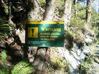
The path traverses above the river and then, turning towards the Rob Roy Glacier, begins to climb through beech forest into the hillside above a narrow gorge.This ascent through beech forest (red, silver and mountain beech are present) is a highlight for any lover of temperate rainforests with ferns, flowers and other alpine plants appearing wherever the forest canopy has been pierced. It is this perpetual change which is a continual reminder to apply caution in the New Zealand alpine environment. Snow can fall at any time of the year and visitors should be adequately equipped if cold weather is forecast. Equally, the higher UV index in New Zealand and the thinner alpine air mean that care should be taken to avoid damaging sunburn by using sunscreen, eye protection and clothing for coverage (a broad-brimmed hat is advised to provide protection for ears). The track is subject to avalanche hazard during winter and spring (June-November) and landslips are not uncommon following heavy rainfall. During a recent visit, three separate areas of the track were subject to warnings and required careful attention to negotiate safely.
The track continues to ascend, always contouring where possible, until it emerges into the head of the valley just above the treeline. Here, the reward is all too evident as the visitor emerges into herbfields. The previous glimpses of high alpine country are now completed with snowfields, hanging glaciers, icefalls, rock walls and waterfalls. The interpretation panels describe how this amazing landscape emerged as schist mountains from the compressed folded debris of Antarctica. The fauna of the New Zealand alpine environment is also mentioned - the Kea - New Zealand's alpine parrot. Cheeky, inquisitive and destructive, the kea is a protected species and visitors are warned not to feed them.
Other bird species are evident too - the Rock Wren/Tuke, Rifleman/Titipounamu, Bellbird/Korimako and Fantail/Piwakawaka amongst them.
Linger awhile here and the visitor will be treated to the sounds of a changing mountain environment as rock, ice and water begin their inevitable descent down to the distant sea. All-too-soon, it is time to descend...taking memories and photographs... and leaving only footprints behind.


